Extend Your Drone Season
Add Forestry Analytics to Your Service Offering
Agricultural spraying can be highly seasonal. Your drone business doesn’t have to be. Adding forestry drone services can help you extend your operating season, reach new customers, and generate revenue outside the traditional spray season.
Biodrone transforms properly captured aerial imagery into measurable forestry information, including tree counts, stand density, height data, damage assessments, and reforestation monitoring.
Biodrone is represented in North America by Canopy Dynamics, with Quantum Drone Systems supporting agricultural drone operators interested in expanding into forestry services.

Put Your Drone Experience to Work in Forestry
Agricultural applicators already have many of the skills required to operate successfully in forestry:
- Commercial drone operations
- Mission and flight planning
- Working across large and remote properties
- Managing customer projects
- Capturing consistent, usable data
- Delivering professional results
With the right mapping equipment, workflow, and analytical platform, those skills can be expanded into forestry, vegetation management, and environmental monitoring services.
Forestry Services You Could Offer
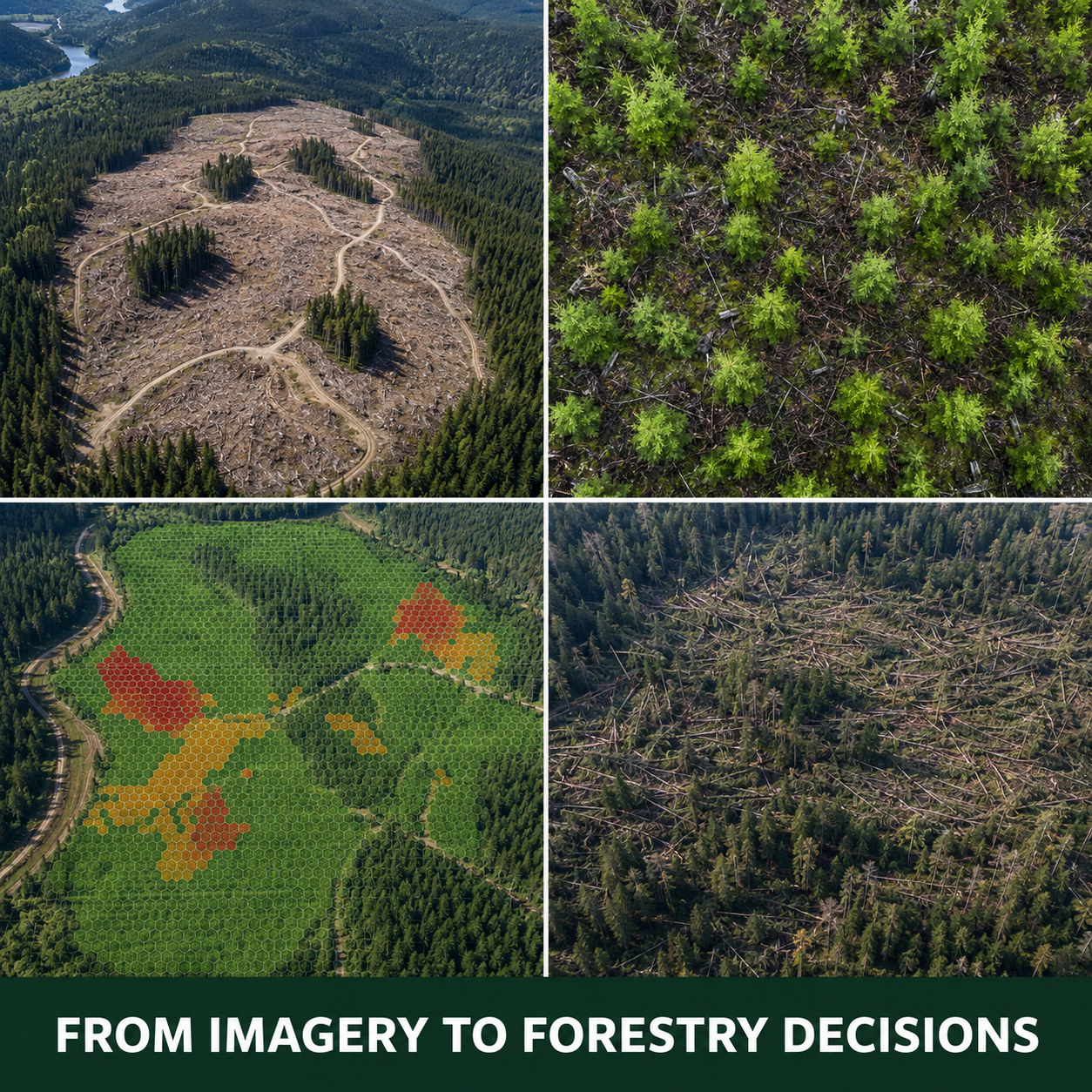
Reforestation and Stocking Surveys
Capture imagery of newly planted and regenerating areas to identify saplings, assess stocking levels, and locate potential gaps.
Tree Counts and Stand Density
Provide mapped tree counts and density information across an entire surveyed area.
Storm and Damage Assessment
Help forestry organizations identify and document windthrow, mortality, storm damage, and other visible disturbances.
Post-Harvest Documentation
Create current aerial records of harvested areas, retained trees, boundaries, access routes, and site conditions.
Vegetation and Corridor Mapping
Support vegetation monitoring along utility corridors, roads, rights-of-way, and other managed areas.


Turn Imagery Into a Professional Deliverable
Depending on the project, Biodrone analysis may produce:
- Tree and sapling detections
- Tree counts and density maps
- Height and canopy information
- Damage and disturbance mapping
- Georeferenced project documentation
- GIS-compatible outputs
Instead of simply handing over photographs or an orthomosaic, you can provide information that supports planning, inspections, reporting, and field decisions.
You Bring the Opportunity. We Help You Close It.
Moving into a new market can be challenging when you are expected to learn the technology, understand the customer’s needs, prepare the proposal, and close the sale entirely on your own.
Quantum Drone Systems will work alongside participating operators throughout the sales process.
Bring us a qualified forestry opportunity, and we can help with:
- Initial customer discovery
- Identifying the right Biodrone application
- Explaining the analysis and deliverables
- Demonstrations and technical discussions
- Project scoping
- Proposal development
- Addressing customer questions and objections
- Supporting the opportunity through to close
You maintain the local customer relationship while gaining access to the product knowledge, sales support, and technical resources needed to confidently present Biodrone.
When an opportunity you originate becomes a paying customer, you benefit financially under the applicable QDS reseller or referral arrangement.
This is designed to be a collaborative sales model, not a software handoff.

Build the Right Forestry Setup
Moving into forestry mapping does not require the large trailers, tanks, and mixing systems used for agricultural application work.
In many cases, forestry operations call for a smaller, mobile setup that can support mapping flights, battery charging, equipment storage, and remote field operations.
Quantum Drone Systems can help determine:
- Whether your current drone equipment is suitable
- What mapping drone or imaging sensor may be required
- What equipment can be reused from your existing operation
- Which charging and power systems best fit the workflow
- How to transport and organize the equipment efficiently
Compact QDS systems, including the Teeny Tiny Tender, can also be configured as practical mobile charging and field-support stations.
The goal is not to sell you more equipment than you need. It is to help you build a practical setup that matches the services you intend to offer.
Build Revenue Beyond Spray Season
You don’t need to become a forestry company overnight.
Start with one clearly defined service, bring QDS a qualified customer opportunity, and work with us to develop the sales, equipment, data-capture, and analysis workflow.
Quantum Drone Systems can support you with:
- Biodrone software and technical guidance
- Hands-on help developing and closing opportunities
- Mapping and imaging equipment
- Mobile charging and field-support systems
- Practical guidance for building a repeatable forestry service
You bring the local relationships and opportunities. We help you turn them into services you can confidently sell and deliver.
Frequently Asked Questions
Do I need to sell Biodrone completely on my own?
No. Quantum Drone Systems provides hands-on sales and technical support for qualified opportunities you bring forward.
How do I benefit from a customer I introduce?
When an opportunity you originate becomes a paying customer, you participate financially according to the applicable reseller or referral arrangement.
Can I use my agricultural spray drone?
No. Spray drones are not designed to capture the structured, high-resolution imagery required for forestry analysis. A dedicated mapping drone is required.
Do I need forestry experience?
You need to understand the service you are offering and the customer problem being addressed. QDS and Biodrone can support the technical and analytical side while you maintain the local customer relationship.
Can I start with one forestry service?
Yes. Beginning with one clearly defined service, such as reforestation monitoring, post-harvest documentation, or storm-damage mapping, is the most practical approach.